
40+ Perspective-Changing And Unusual Maps That Portray The World In A New Way
Maps have the power to change our perspective on the world. They are an effective and unique tool, especially for visual learners, for understanding the vast rock we call Earth. Maps allow us to take a glimpse at our world’s secrets and most incredible places from the comfort of our own homes.
An innovative corner of Reddit is dedicated to these worldly maps, and the cartography fans are going crazy over it. They delve into treasure troves of long-lost civilizations, complicated statistics, and rich history. From food facts to the most popular travel destinations to maps about nature, they cover it all in a bid to open our minds.
To expand our horizons and unleash our inner adventure, we’re delving deep into some of the most exquisite maps we’ve ever seen! The visualizations are awe-inspiring, and you can mark our words that you never saw any maps like these in grade school!
Antarctica At The Center
There are seven continents around the world. Six of them happen to be very inhabitable yet home to many cultures and peoples. The 7th continent, Antarctica, is a bit of an outlier for a very clear reason. It’s bone-chilling cold!
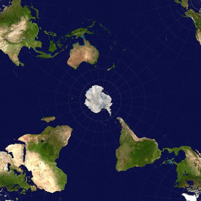
Antarctica has no permanent inhabitants, most likely because it isn’t the warmest place to put your feet up. While Antarctica often looks big on most maps, this one is sure to change that. This map places Antarctica right in the center of the world and is pretty tiny.
Most Popular Surnames In Europe
Surnames or last names are certainly an interesting subject, even though they are not always thought of as thought-provoking. Surnames not only provide you with a starting point from which you can trace your ancestry but also your cultural history.
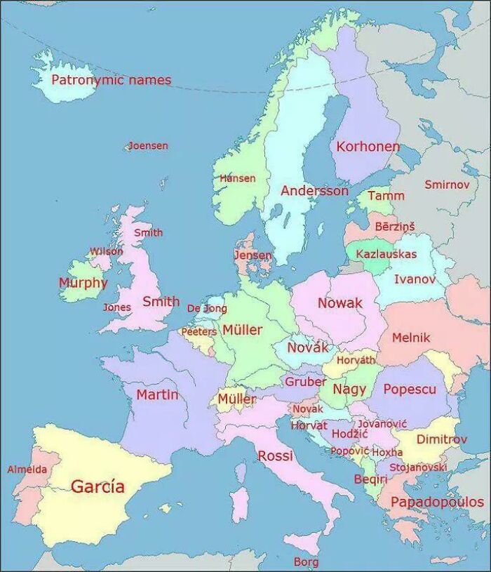
Many surnames are odd. Some of them were once professions that later became names, like Smith. Others were names for natural features or objects that no longer match their modern equivalents. This map gives you a glimpse of some popular European surnames.
Nature’s Map
While on the topic of interesting things, maps themselves are quite a fascinating creation if you think about it. People tried to make sense of their surroundings in a time when there was no internet. Because of this, mapping was born.
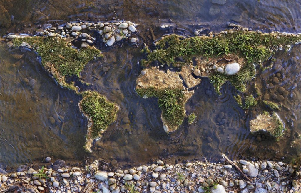
Maps are simply representations of the natural world around us, brought to life by ink or code. Millions of maps and styles have been produced and brought to life over the millenniums. However, we would argue that few look as natural as this.
A Map Of The HRE, Before Germany
The modern country of Germany, as a united entity, is relatively young when compared to other European countries. This has to do with Germany only being united in 1871 by German statesman Otto Von Bismarck. Before then, it had many names.
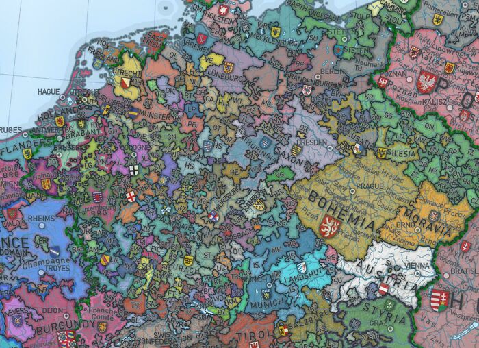
One such noteworthy name, or political entity, that laid claim to the land was the Holy Roman Empire (800-1806). The empire was not very organized or stable, as you can see by the hundreds of dukedoms, baronets, and states that made it up.
Most Popular Browsers In The World Between 2012-2022
Modern technology and the internet are now so heavily integrated into our lives that it’s hard imagining life without them. Just as the internet has shaped many facets of our lives, we, too, have shaped it by ourselves. Read on to see how.
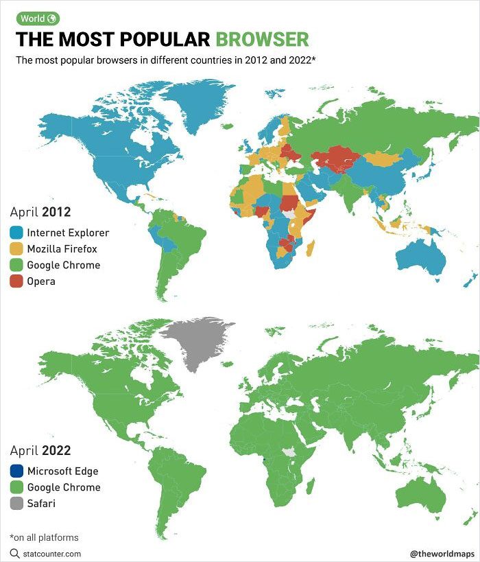
Looking at this map, you can see that many different browsers fought for dominion of the internet. 2012 shows how Internet Explorer, Opera, Chrome, and Firefox all fight for it. By 2022, however, it’s no longer a contest for Google Chrome.
Child-Friendly Curse Words From Europe
Kids swear. There’s no way of avoiding that truth, just as there is no way to stop them from learning. However, there are a few “kid” friendly curse words that also exist – euphemisms, if you will, and they are interesting.
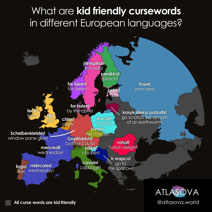
This map shows some of the most popular children’s swear words within Europe. Most are modified and blameless versions of the proper (and ruder) word that adults no doubt use. Unfortunately, a lot of the humor is lost due to language barriers.
A Map Showing The Population Density Of Africa
Africa is home to an enormous amount of people, with censors estimating the population of Africa to be roughly 1.4 billion. Fortunately, the continent of Africa has more than enough space for such a population. But unfortunately, not always the resources.
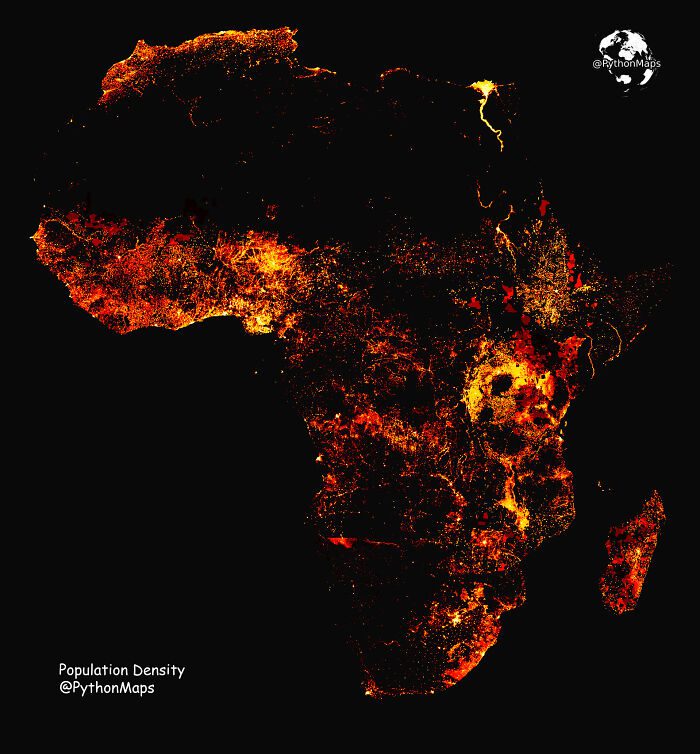
While Africa might be extremely rich in minerals and precious metals, not all of the continent is resource-rich. A consequence of this is that many people end up living on top of each other in their respective capital cities.
Places In Europe That Will Offer Food To Guests
The spirit of hospitality is an old value, with tales of its importance undoubtedly shared across many cultures. However, not all places, cultures, or traditional values are as ready to feed a stranger as some others would be.
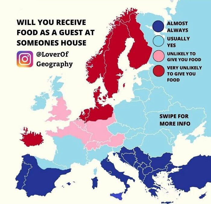
This doesn’t mean that the people are rude. Instead, it is a centuries-old habit, born from a time when food was less plentiful. As you can see, northern Europe is less likely due to the bitter and harsh winters they had to endure.
All The Bicycle Lanes In The Netherlands
If you’re from the US, you likely know that having a car is essential to doing anything. This is because the US is just too massive, with cars being the only viable means to travel long distances.
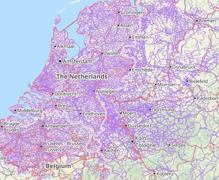
In contrast, in many places in Europe, you will find the opposite to be true. A fact which is hasn’t been as clear as now you can see in the Netherlands. All these purple lines are actually bicycle lanes that stretch all across the tiny Dutch country.
The Most Populated Areas Of Australia
Speaking of big counties, Australia isn’t exactly a tiny place either. Although it has the advantage of having the whole continent to itself, most of the country is particularly inhabitable or unsustainable for large groups of people.
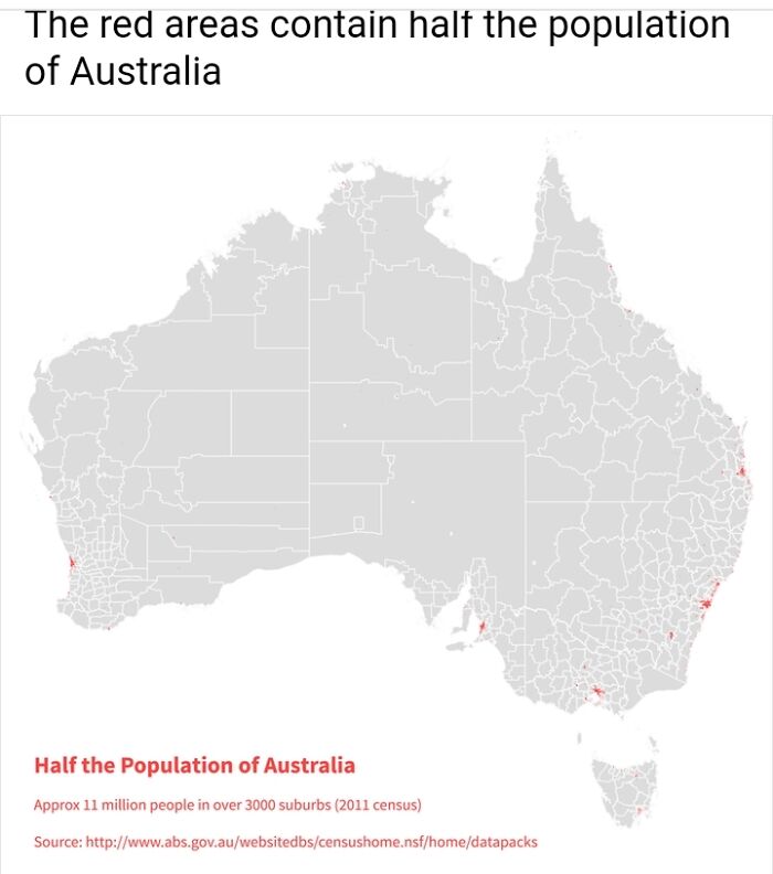
This is due to Australia having some extremely poisonous animals and really dry land with little rain. This means that 11 million people, half of the country’s population, live within the red markers. Which basically looks like 1% of the country’s landmass.
The Weird Dinner Times Of Europe
Most people take their mealtimes pretty seriously, whether that includes all three daily meals or just one of them. And we probably know one person (or are that person) that gets a little angry when they are hungry or not fed.
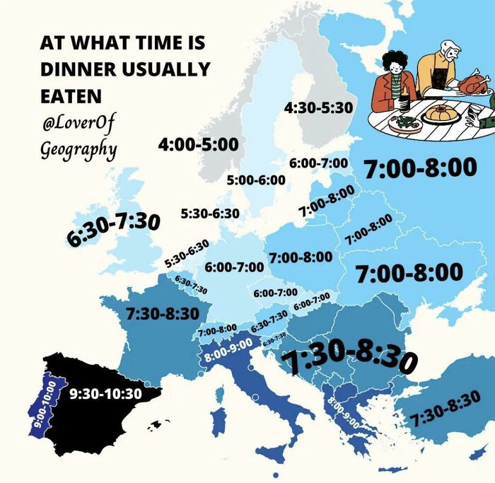
It’s probably safe to say that these people might not fare so well while traveling through Europe. Take a look at this map of Europe’s standard dinner times to see why. Some of them just seem completely ridiculous and absurd!
Coffee Consumption Of Europe
You can’t argue that coffee is one of the most popular drinks out there. Even if you aren’t a fan, millions of people in the world can’t go a day without it. This cool infographic shows just how popular it is in various European countries.
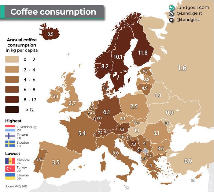
While you no doubt imagine Italy as being the top consumer, they are actually nowhere near the top. That honor goes to the Nordic or Scandinavian countries. We wonder if it has something to do with how cold it is up there!
European Average Male Height
Height. That holy grail for many young boys growing up and a bitter reality for many adults. No matter where you are, most likely, every guy wishes they were just a bit taller. That is unless they’re Northern European or Scandinavian.
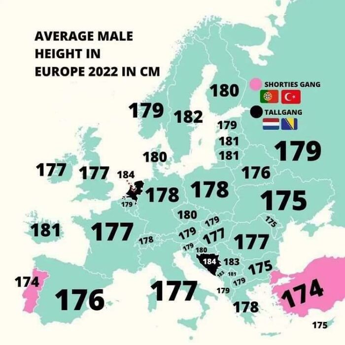
Looking at this map of the average male heights across Europe, you can see what we mean. Not saying southern Europeans are short (definitely not the Bosnians), but they’re nowhere close to the Dutch, the Germans, or the Scandinavians.
All The World Cup Winners
The World Cup is arguably both the biggest and most anticipated sports event in the world. A quality that it has fostered over the last 90 years. It also attracts fans from all cultures and corners of the world regardless of age.
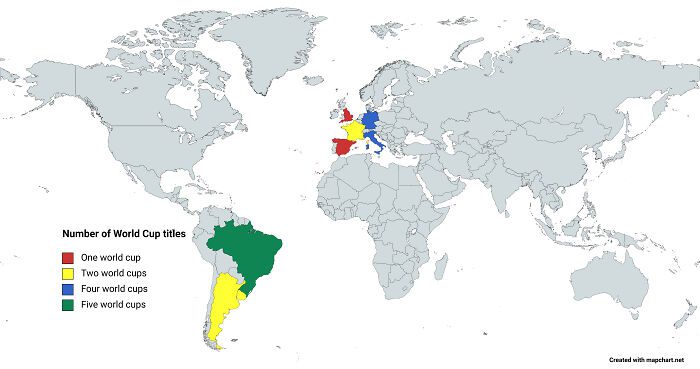
Now, while it might be a game involving the whole world, very few countries have actually won the trophy. Or rather, it seems the few same countries keep winning it, specifically countries from Europe and South America. Especially Brazil and Germany.
Most Popular Unisex Names In The US
It would seem that naming your child is either one of the simplest or most difficult tasks you can be faced with. Some people just know the right name. Others spend months deciding on one. And others only realize it once the baby is born.
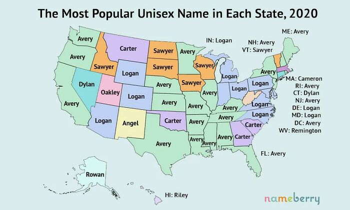
And while there are hundreds, if not thousands, of names out there, these few names keep popping up. Yep, these are the most popular unisex names within each state of the US. And no offense, but we are unfamiliar with some of these names!
Most Popular Street Foods In Europe
While street food might be a bit out there for some and a mess for others, it has an unmistakable charm. The fact remains that they are a life saver after spending the whole day sightseeing or rushing between work or appointments.
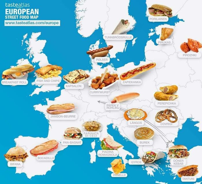
In case you were curious, here is a map with some of the most popular street foods across Europe. Two things are quite common between them: bread and meat! We don’t know about you, but we’re hungry right now.
Map Of European Countries Marked With The Flag Of Their Capitals
National or the flags of different countries are fairly well known, but did you know they weren’t the only ones? Many cities, states, and provinces have flags of their own as well, especially for the capitals of their nations.
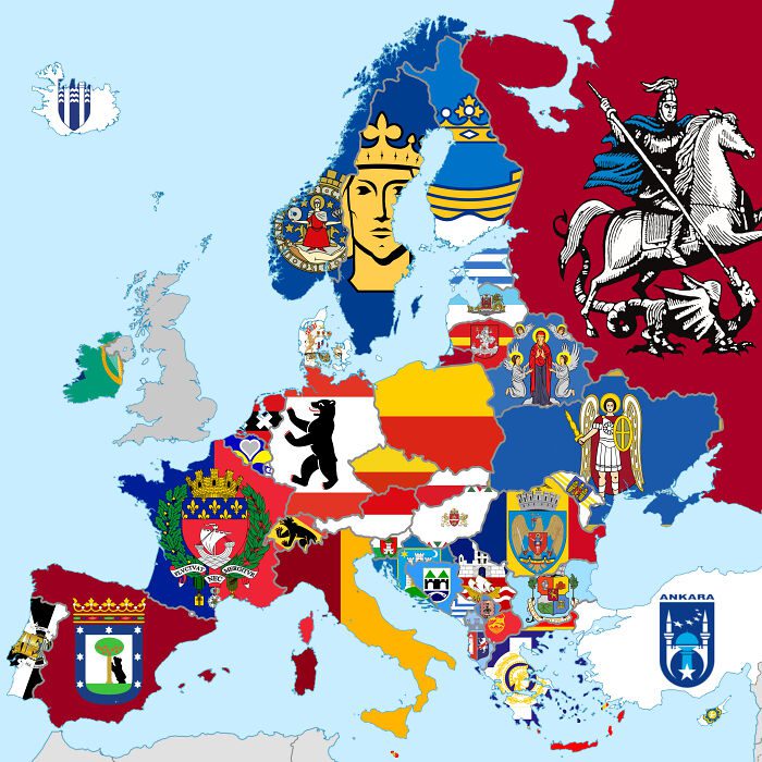
Here we have the flags for almost all the capitals of Europe, excluding the UK. One thing is for sure; they are definitely far more interesting than their blander national flags. They just have so much more character and life.
50 Of The Strongest And Weakest Passports
This next map isn’t terribly detailed or informative, but it’s still interesting. Here we have a collection of 100 passports, 50 of the strongest and weakest. That said, this map does not offer a very detailed breakdown. But let’s still explore it.
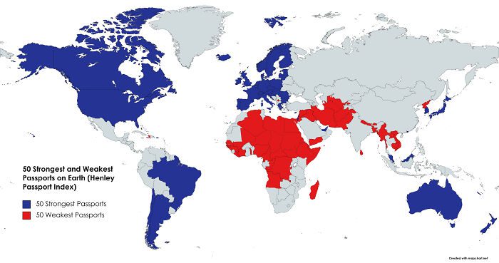
The countries highlighted in blue denote the 50 countries with the strongest passports in the world. This includes most of the Western world and Latin America. Those in red denote the 50 weakest passports from Africa, the Middle East, and parts of Asia.
Percentage Of Europe With Street View Coverage
Right. Some of the more privacy-conscious of you might find this one eery, whereas others might find it cool. Here we have an infographic map that shows how much of Europe has street view coverage. It is quite extensive.
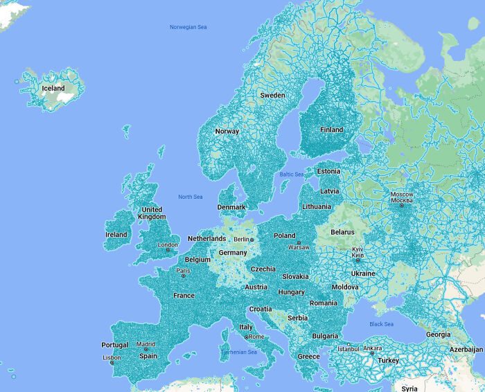
The vast majority of Europe is, as you can see, completely covered with street view satellite imagery. The only exceptions are parts of Scandinavia, Iceland, and Russia due to their large uninhabited spaces. Germany is also an exception due to stricter privacy laws.
Europe’s Most Popular Passwords
This infographic map supposedly shows the most popular passwords within Europe. We say ‘supposedly’ because it is hard to determine its accuracy or credentials. Yes, it might have the ‘Nord VPN’ logo, but anything and everything can be faked nowadays.
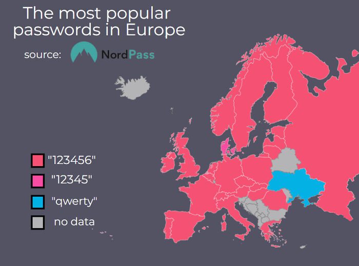
Regardless, according to this map, most of Europe uses a simple one-six number pattern, while Ukraine uses letters. We question this map because, indeed, with all the internet vulnerabilities out there, people would have some more common sense.
Top 3 Most Popular Countries To Travel To In The World
The world is full of dozens of fascinating places and locations that attract millions of people to them each year. Some countries, however, are a little more popular than others. The three most popular destinations are Japan, Canada, and Spain.
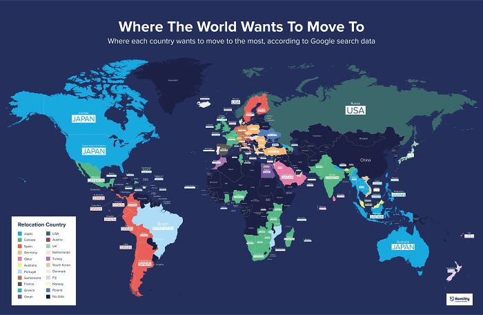
It’s not hard to see why. Each country has something unique to them that acts as human pollen or catnip. The results were apparently tabulated by analyzing the monthly searches for these destinations from within each country. Also, feel like traveling soon?
The Current VS. Historic Range Of The Grizzly Bear
The grizzly bear is a species native to North America and is one of the largest of its kind. Today the grizzly bear is confined to Alaska and the northernmost areas of Canada. That’s a drastic reduction of what they used to roam.
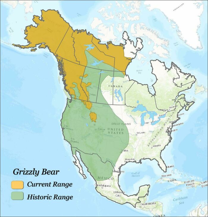
Decades ago, before the incursion of humans onto the continent, the grizzly roamed through much of Canada and the USA. They would travel from Alaska all the way to Mexico in droves. Only to be chased away by the advancement of humans.
Countries With The Densest Railway Networks
Railway Networks started to pop up all over the place following the use of coal transportation during the Industrial Revolution. While things have changed a lot since then, the popularity of railway transportation has only grown, as you are about to see.
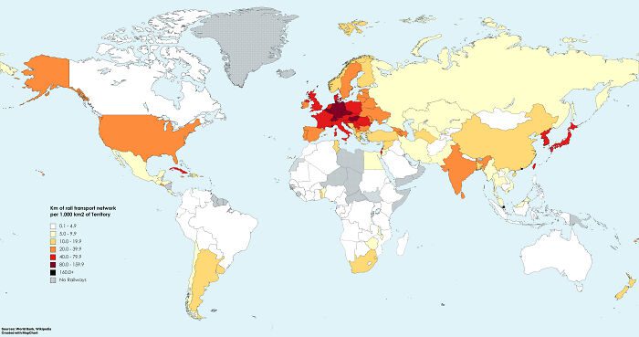
This is a color-coded map of the countries with the densest concentration of railway networks. Much of Europe, Korea, and Japan is at the top due to the popularity of public transport within those areas. It’s convenient and more environmentally friendly.
The Gender Of Countries According To Greek
Many languages use what you could roughly call a gendered naming system. Now, gender has taken on a new meaning within modern America; its use in language is very different. These systems were used to make sense of then developing languages.
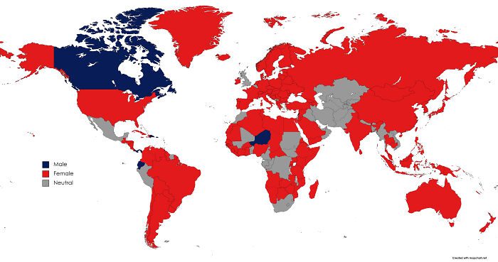
This is a common feature for almost all Indo-European languages, a language family that stretches from India to the UK. This map shows what each country’s gendered suffix would be if written/spoken in Greek, with most countries having a female suffix.
One Main Avenue Shared Between Brazil And Uruguay
Brazil and Uruguay share a lot of residential areas due to the nature of their borders. One famous example is this single Main Avenue that runs through the border and is shared by each country. Specifically between the cities of Chuy and Chuí.
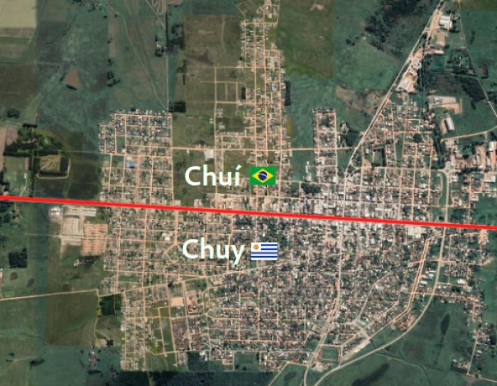
Chuí is a Brazilian city, whereas Chuy is Uruguayan. Both cities are independent of the other while still coinhabiting the shared space. It is in places such as these where you can hear Portuñol or Portunhol, a mix between Portuguese and Spanish.
A City Map Of Montreal Made With One Line
Okay, this next map is quite impressive. Rather than draw a simple city map of the Canadian city of Montreal, this person went to the next level. What might look like random squiggles is actually one long and uninterrupted line.
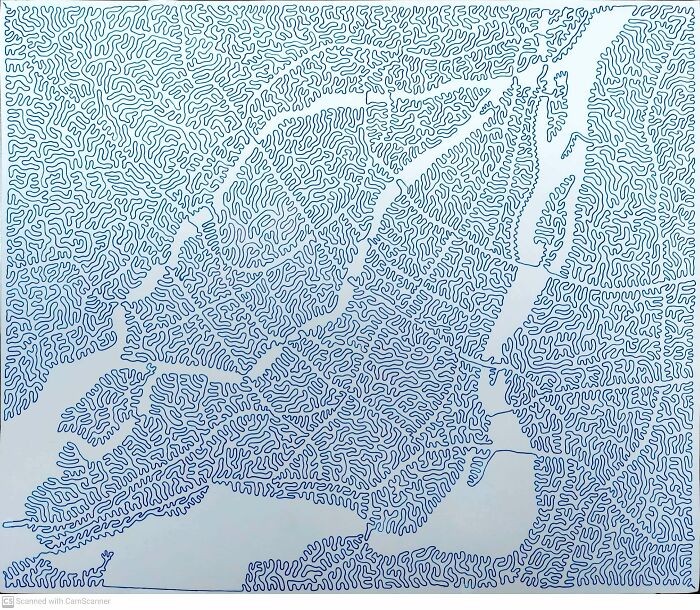
Yep, this person drew the entire city map of Montreal without starting from different points. A feat which is seriously impressive and a testament to their dedication. We can only imagine how much of a headache it must have been to make.
The Number Of Riverbeds In Australia
The beauty of sciences like geology is that they uncover and make sense of ecological features that once were. Today, Australia might have a reputation for its extremely dry and hot climate. It’s a desert island, as some like to think.
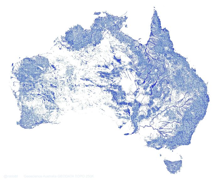
The truth is that Australia used to be covered with dozens upon dozens of rivers that spread across the land. Rivers that, sadly, become dried up at one point during its long history. This map shows what would have been.
Colored Countries That Are Smaller Or Larger Than Their Neighbours
Okay, this map is still interesting, but it could have been so much better had the creator executed it better. What we have here is a colored map that shows which countries are larger or smaller than their immediate neighbors.
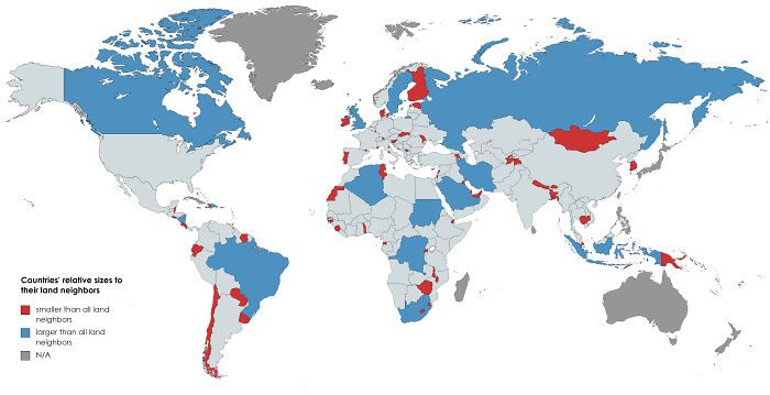
Blue denotes countries that are larger than their neighbors, red for those that are smaller, and grey for non-applicable. At first, it works, and you see who is who in terms of size. However, it gets confusing quickly because of the non-applicable ones.
Shaded Relief Of Antarctica
Antarctica. The world’s seventh continent and a land that has attracted explorers for decades. It’s an attraction in itself, but let’s not forget the fact that it is the coldest and driest place on Earth. We cannot even imagine what it must feel like there.
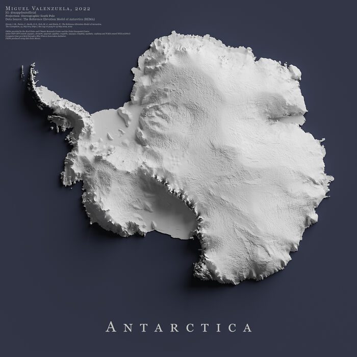
One individual took this attraction and made a particularly creative work of art. This is a shaded relief of the continent. A relief that shows all of its bumps and lumps while hammering the point home that the land really is barren.
Most Popular Dog Breeds In The USA (edit)
Dogs are often regarded as some of the best companions you can have around, and rightly so! They aren’t called man’s best friend for nothing. It should come as no surprise that there are nearly 90 million dogs in the USA alone!
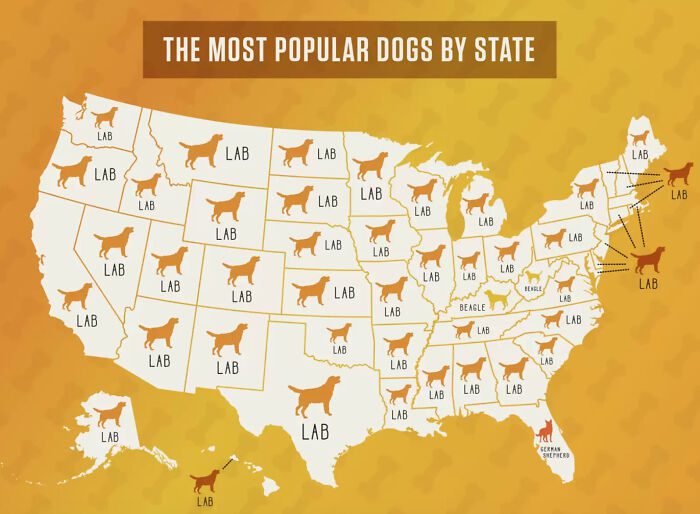
Suffice to say that the USA is a bit doggy obsessed. So much so that a study was done to find the most popular breeds within each state. The results were surprising. We wonder if there was a mistake at the lab?
Pigs Per KM2 In Europe
This bizarre-looking map is an infographic on an equally bizarre topic; the number of pigs per km2 in Europe. Yep. Someone actually took the time to measure that. Unfortunately, while it is interesting, it’s also hard to look at.
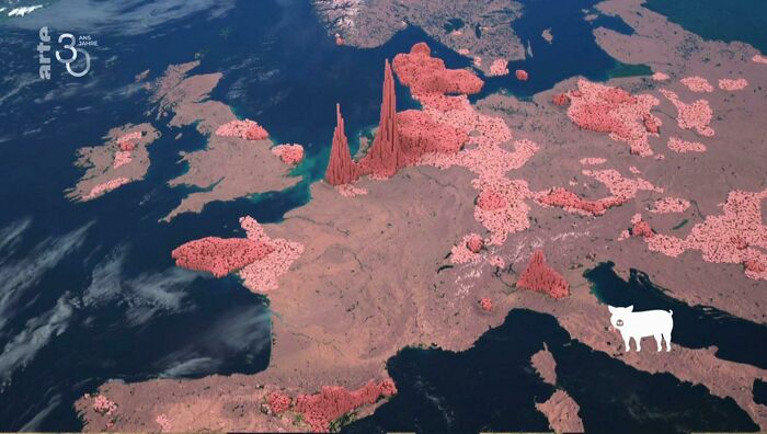
What this infographic does show is the disconcerting fact that many of these pigs are stuffed into small living areas. The areas around the Netherlands and Denmark appear to be the most egregious with their tower spikes of digital pigs.
The Possible Spread Of Ash If Yellowstone Volcano Ever Erupts
The Yellowstone National Park in the USA is home to the largest super volcano in North America. The Yellowstone Caldera, as it is called, last erupted around 640,000 years ago. That said, the volcano could still erupt again in the future.
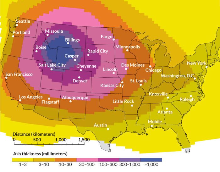
This shocking infographic shows us how much ash would be released and how far it could spread if it erupted. As you can see, the released ash is capable of covering the entirety of the USA. Let’s hope that never happens!
The Valles Marineris Of Mars
The Valles Marineris is a gigantic canyon system that stretches across the surface of the planet Mars. With a range of 4000 km and a width of 200 km, it is the largest known canyon system in the solar system.
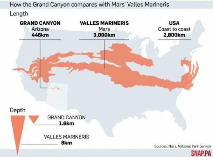
This map shows us just how long the Valles Marineris would be when compared to the geography of the USA. As you can see, the Grand Canyon is nowhere near its size, which is long enough to cover the USA.
Where You Can Find Palm Trees In The USA
Palm trees are one of the first things that you think about when picturing a beachside and tropical resort. While many people often quote that these palm trees were introduced to these areas, that is not completely correct. Kind of.
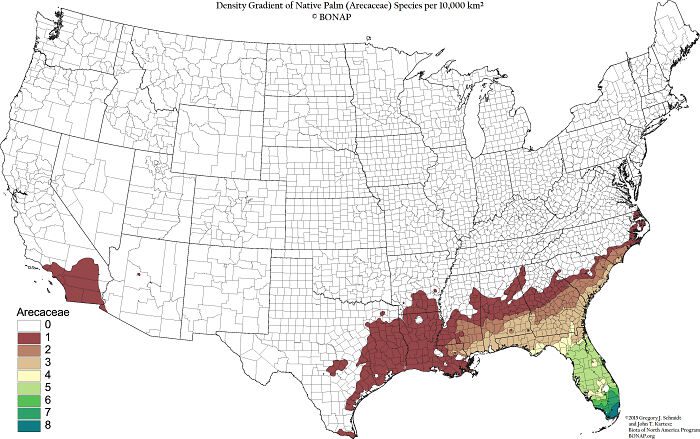
Palm Trees are an incredibly old species that can even be traced back to the dinosaurs. Additionally, they can be found in just about all tropical and subtropic areas (with some exceptions) across the globe, like the subtropical regions of the USA.
Percentage Of Young People Living With Their Parents
This one is interesting, but not without its issues due to a lack of context. Here we have an infographic map that shows how many people still live with their parents. It’s a trend that is becoming increasingly normal due to financial pressures.
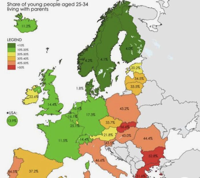
The reason for this is due to the ever-increasing prices of property and everything else in general. Also, this infographic does not say when it was made and if it’s still accurate. This means that the figures might be far higher than shown here.
A Map That Shows How Long Chile Is
When we think of Chile, we often imagine it as being quite tiny. That is if you know where Chile is and what it looks like in the first place. The truth is that Chile only looks small when compared to the Americas.
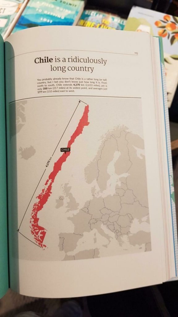
As the country is actually quite large, something this visual map shows us. As you can see, Chile is a long country and has the same length as Europe (from Portugal to Norway). It just shows you that perspective is really important.
The Shortest Flight Route From Ulaanbaatar, Mongolia To Santiago, Chile
Maps are fascinating things. They provide us with visual representations (2D albeit) of the world that don’t always show things as you would expect. Here we have a map that shows the shortest possible flight route between Chile and Mongolia.
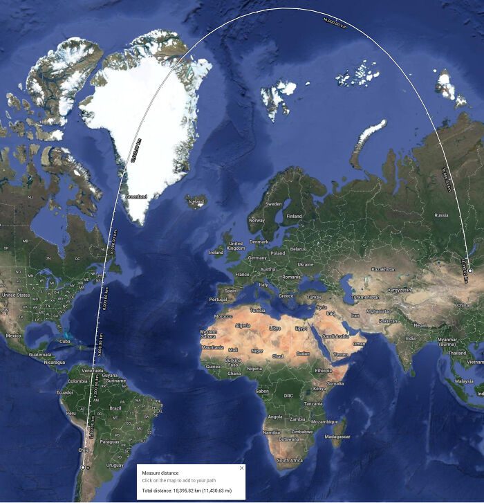
Now you are probably thinking that this doesn’t make sense. Wouldn’t it be shorter to fly through Africa? Well, no, because maps do not consider the spherical nature of the globe. Meaning the distances we see on a map don’t reflect reality.
How Permanent Daylight Savings Would Chang Things
Alright, this next one is really confusing. At least for us, maybe you will have an easier time with it. What you’re looking at is a colored infographic of what sunrise and sunset times would look like in the USA.
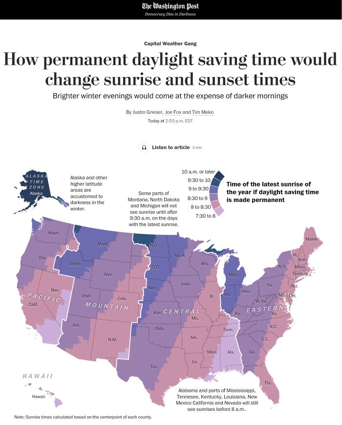
That is, what it would look if daylight savings were made permanent. Using the color key, we can see that some states will have sunrise at 7-8 am. While others will only see daylight at around 10 am! Again, it’s really confusing.
A Map Of Countries With Absolute Monarchies
When thinking of monarchies, it’s safe to say that the British royal family and Queen Elizabeth are the most famous. While they might be the most famous, they are not the most powerful. This is due to the United Kingdom being a constitutional monarchy.
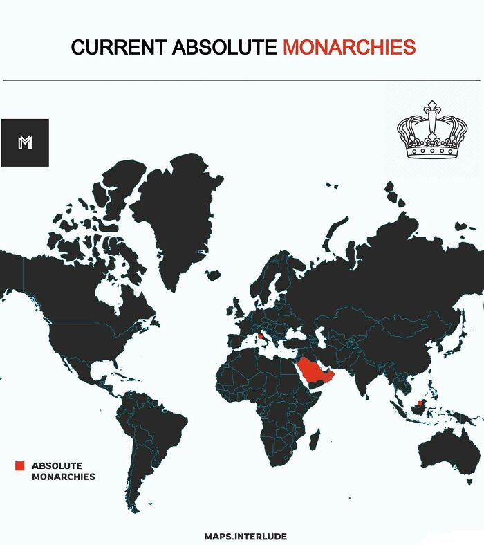
The UK transitioned from an absolute monarchy to a constitutional one in 1688. That said, there’re still some absolute monarchies in the world, which this map shows us. It includes Brunei, Eswatini, Saudi Arabia, and Vatican City (yes, the pope is a monarch).
A Map Of Certified Neapolitan Pizzerias From Around The World
When it comes to food, the Italians take it very seriously, especially when it comes to their own food and ensuring that everything is kept very traditional. They take this matter so seriously that there is actually a pizza international association.
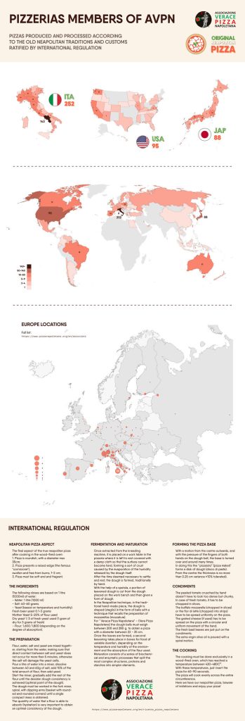
The Associazione Verace Pizza Napoletana is an associative body that regulates what can be called an authentic Neapolitan pizza. Looking at this extensive infographic, we can see all the countries that serve certified Neapolitan pizzas, with over 250 restaurants in Naples alone!
McDonald’s Opening In Europe
McDonald’s is undoubtedly one of the most popular fast-food chains in the world. Having been in existence for over 80 years now, this franchise has built a name for itself as a successful company as well as a restaurant that always has your back whenever you’re craving a hamburger.
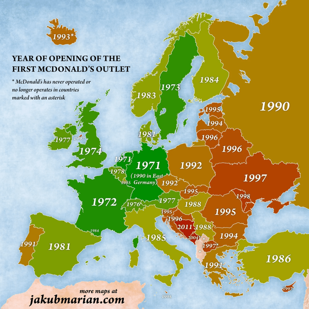
Though the first McDonald’s was opened in 1940, it took about 30 years for the business to cross the pond over to Europe. The first ever outlet in the continent was opened in the Netherlands in 1971, and since then, the company has launched thousands more in close to 40 countries.